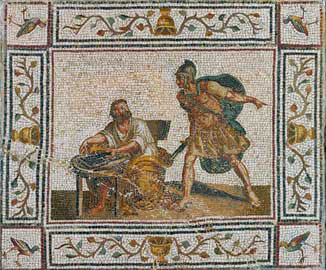
 ancient mosaic, 16th century Important presentations by renowned scientists were presented during the three-day international symposium held on 10-12 September 2007 in Patras on "Archimedes of Syracuse - Two-way cultural influences of Western Greece, Ionian Islands, Apulia and Sicily" through history. The symposium was organized by the Institute of Culture and Quality of Life (IPOPOIZ) in collaboration with the Region of Western Greece, at the Conference and Cultural Center of the University of Patras. The work of the conference began with the presentation of the internationally renowned emeritus professor of the Metsovi Technical University, Theodosi Tassios who referred to the multidimensionality of Archimedes' intellect, which shaped mathematical science not only, but also its influence over time.
|
|
The Atlantis HypothesisBrief presentation of views and speeches delivered during the two-day conferenceAbout 51 papers are contained in the volume of proceedings published for the 2nd International Conference, "The Atlantis Hypothesis: Searching for a "lost Land," held on November 10 and 11, 2008 at the National Research Center in Athens. There were three categories of speakers: the first examined the platonic style of writing from the standpoint of philosophy and art; the second considered Atlantis an occurrence of 12000 years ago, and the third presented Atlantis as an event of Bronze Age. The soeakers offered a range of approaches in an attempt to decipher Plato's Timaeos and Critias. Theopis Parisakis, Associate Professor of Philosophy at the Aristotle University of Thessaloniki, in her paper "The myth of Atlantis and Plato's intentions", estimated that the myth of Atlantis was used by Plato to promote his general political and philosophical-educational aspirations and, in particular, his vision for the revival of an "Ideal Sate". She believes, that the Atlantis' myth functions as another moral, political and philosophical myth. In this context, the leading philosopher, presenting the rise and fall of the mighty Atlantis, just at the moment when it aimed at world hegemony, wanted to spread, among other things, the message that arrogance and greed are a major moral shock and can lead to the destruction of even the most Ideal State. Ms Parisakis supported that "the data which Plato uses, may not even refer to the distant past, but be drawn from states existed in his own days, such as Athens or Sparta". Ms. Parisaki, however, did not rule out the possibility that the myth may have a historical background, or that it was written, at least in part, from historical data. As, as she wrote, "the Atlantic myth is the most detailed and plausible of all Platonic myths". Assumptions about its Location and DatingThe variety of interpretations given for its location was so rich, with the result that Atlantis was placed not only in geographical areas distributed around the planet, from the Mediterranean to America, but also over the centuries, from 1,200 BC. until 10,000 BC. An Italian research team from the University of Milan (M.Negri, G. Facchetti, E. Notti) in their paper, "Creta Thera Atlantis: culture and writing", pointed out that the myth of the "lost country" exists in many peoples and regions of the Earth and may have a real basis, while emphasizing that The myth of Atlantis undoubtedly stands out among all the relevant myths. He also presented data, based on a comparison of the inscriptions of the Minoan and Cycladic civilization, pointing out that their similarities point to the possible identification of the Platonic Atlantis with the Minoan world and consequently Thira (Santorini), which was destroyed by volcano. Among the various other sites proposed on the first day of the conference for identification with Atlantis were: Southern Spain (in the Guadalquivir River region), the Middle Danube region in the Pannonian Plain (the case of a group of researchers Geological Institute of Romania), the Andean highlands in Bolivia (around the area of "Pampa Aulagas"), the island of Hispaniola discovered by Columbus in the Caribbean, Iceland (ancient Ogygia - case of the Greek researcher B. georgiani from T.E.I of Peiraeus), the wider region of Central America (according to Canadian researcher J.Teeluck beneath the pyramids of Mesoamerican civilizations there are stairs leading to underground Atlantic settlements), Northeastern America in the Poverty Point area of Louisiana (view of the Greek researcher A. Kontaratos), etc. Various researchers have referred to a wealth of evidence (e.g., paradoxically, up-to-date ancient maps, such as those of Piri Reis and Orontius Phineas), suggesting that ancient civilizations may have had knowledge of planetary locations (e.g., Antarctica, South America) , which could only ultimately refer to remnants of the knowledge of an older, now extinct, culture, most likely of Atlantis. During the second day of the conference, the presentation of new hypothetical - and often exotic - sites continued, which, according to researchers, could be identified with ancient Atlantis, which sank about 9,500 years ago, according to the famous Platonic myth. . In all, more than 200 sites around the globe claim the "honor" of having hosted the mythical state in the past. Among others, the following sites have been proposed: the Atlas Mountains in the Sahara Desert in present-day Algeria, the Sousa-Masa-Draa region in southern Morocco, the Meroe region in present-day northern Sudan, the Indus Valley region and in particular Dolavira, the Antarctica, the Greek island of Lesvos (off Plomari), the island of Serbro off Sierra Leone, and others. A. Mitrousis from the National Center for Marine Research (ELKETHE) presented a paper on the preliminary results of the Atlantis Program 2003, which concerned seabed research, in 2003. According to the researcher, even if there is historical truth in the Santorini-Atlantis relationship, it is difficult to find evidence at the bottom due to the volcanic alluvium that has a large thickness. It was also pointed out at the conference (E. Mitropetrou, University of Patras) that neither Homer, nor Hesiod, nor Herodotus, nor Thucydides, nor Aristotle make the slightest reference to Atlantis, with the sole exception of Plato, while, on the other , the mythology of a lost ideal state decisively influenced later thinkers and their own utopias, as in the case of Francis Bacon's "New Atlantis" and Thomas More's "Utopia". Among the highlights of the conference were the various works of the British researcher Y. Koak, who reported that the Indian epic Mahabharata contains a strikingly similar destruction of an ancient Vedic civilization (Dwarka) by a tsunami, confirmed by modern research and estimated that there was relevant myth from South Asia to Europe. The Italian researcher L. Monte identified Atlantis with the Minoan civilization and said that Plato essentially told the story of the war between Athens and Crete in the Bronze Age. The German explorer T. Franke preferred to associate the Atlanteans with the mysterious Peoples of the Sea, who invaded Egypt at the end of the Bronze Age, whom he identified as Sicilian and Sardinian invaders. 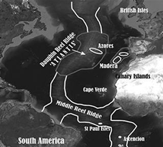 Middle Atlantic Ridge, close to Azores
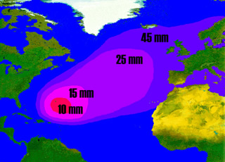
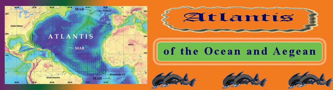
The Figure 1 illustrates the "Dauphin Reef Ridge" on which N. Zhirov and Theodor Paschos theorize that the capital of Atlantis was located. At that point, the mid-Atlantic ridge is shaped like a huge submarine plateau (Azores plateau), just 100 meters below the current average sea level. The submarine plateau has been explored since 1996 and there are several archaeological finds. The Soviet Professor Alexander Gorodnitsky, a marine geophysicist, geologist and oceanographer, surveyed the azores plateau which is only 100 meters deep with respect today' s mean sea level. |
Τhis year's conference for Atlantis was dedicated to the memory of Professor Antonis Kontaratos, who, in addition to his intense activity inside our country, excelled in many interdisciplinary programs in the USA (NASA, national energy program, national anti-AIDS program, etc.). A total of twenty lectures were given, of which ten, were given by Greek speakers and thirteen by foreigners, coming from countries such as France, Germany, Italy, Romania, Norway, Spain and Australia. It is worth mentioning that the English language was used for all presentations without exception. The professor of Geology of the University of Patras and president of EMAEM, Stavros Papamarinopoulos, was the one who introduced the public to the "problems" faced by the Atlantis case. He argued that: "Despite the complexity of the issue of the lost continent, Atlantis existed and, in fact, at the same time, along with a strong Athens, during the 12th pre-Christian century. The question that arises is why the historians of later centuries do not mention it ... Could all these detailed descriptions of the city of Atlanteans by Plato be exclusively imaginary or symbolic thoughts of the great Greek philosopher?" The first purely scientific researchDuring this international conference, the findings of the virgin scientific study conducted in a real place to search for the legendary continent were presented for the first time. The speech was given by the Frenchman Marc-Andre Gutscher of the French National Center for Scientific Research (C.N.R.S). It presented the methodology used during explorations to the bottom of Spartel Island, just a few miles outside the Straits of Gibraltar. The scientists did not find any evidence of a sunken state, yet all in attendance noted the enormous importance of conducting a study of this level that scientifically upgrades the issue and paves the way for similar efforts in the future. Gutscher did not fail to point out that Plato's descriptions of the destruction of Atlantis correspond to those of a powerful earthquake and tsunami in 1300 BC. Problems with terminologyOne of the speeches that caused a sensation was that of the electronic engineer and member of EMAEM, George Sarantitis. The Greek researcher raised the issue of the many and different "quality" translations of the Platonic texts (especially the "controversial" Timaeus and Critias) that create misunderstandings over time on the issue of Atlantis. He characteristically emphasized that the Greek philosopher does not speak at any point about the sinking of the lost continent, a fact that has turned the research for its search in the wrong directions all these years. In addition, Mr. Sarantitis presented a graph in which he showed that Plato uses in his texts a kind of "testing" of the reader, harmonizing (in terms of difficulty) the semantic content of his work. Finally, through a literary analysis, he "showed" the bay of Gabes on the east coast of Tunisia, as the real "Pillars of Heraklion". For his part, Professor Papamarinopoulos pointed out the different meaning of the word "island" in antiquity, which was not completely identical with the corresponding today. For example, it was sometimes associated with the word "peninsula", a term that was interpreted differently only in the 5th pre-Christian century by Herodotus, while other times it was used to denote rivers (see Ladonas) or even cities. This fact could of course create new data regarding the search for the "island of Atlantis" by modern scholars. The "heretical" case of RussiaOne of the ... strange theories that was presented was that of the Italian Marco Bulloni who "placed" Atlantis on the Russian islands of Solovetsky in the White Sea (very close to the border with Finland)! The independent researcher from the neighboring country used a rather convincing argument that included a literary analysis of Plato's descriptions, while making the necessary comparisons from his own field research in northwestern Russia. It is worth mentioning that on the central island of the complex (the largest of the six) there are to this day labyrinthine underground labyrinths and a multitude of megaliths and petroglyphs that could have been built by an advanced civilization of antiquity. According to Bulloni, there are signs of destruction and sinking of a significant part of the island by a tsunami, while the age of this event is determined in 1300 BC. Homer and the astronomical data!At the conference on Atlantis we also attended some very interesting talks about the astronomical parameters of the adventures of Odysseus and the sea routes of Homer's time. The truth is that many wondered about the presence of this purely Homeric data in the program, yet in the end they understood the usefulness of these studies. The show was stolen without a doubt by the presentation of Panagiotis Antonopoulos (physicist) and Eleni Mitropetrou (archaeologist) regarding the determination of the exact time of the Odyssey events based on the combination of the literary analysis of the texts and the astronomical phenomena described. . The calculation of the return of the versatile hero to Ithaca was determined in the Autumn of 1207 BC, very close to the solar eclipse of October 30 of that year. The astronomical programs and mathematical formulas used demonstrated in the best way the valuable help that "hard science" (as it was characterized) could offer, namely physics, mathematics, geology, etc., in the work of philologists and archaeologists. Similar methods could be used in the future (even with the little data we have at our disposal) to search for Atlantis. Faced with paraphilologyDuring the round table of participants, which was the last section of the Santorini conference, the question of paraphilology related to the supposed nature of the lost continent and theories about technologically advanced (with the current data) or even extraterrestrials Atlanteans was raised. Gutscher's radical proposal caused a sensation, which urged the organizing committee to invite such researchers to the conference from now on, so that their theories would be put under the ... "microscope" of the rest. Pending a new surveyThe second scientific study in search of historic Atlantis is currently underway. U.S.A. researchers are searching for the submarine and coastal area of the Costa de la Louth Peninsula in Andalusia, at the mouth of the Guadalquivir River. In the subsoil of this area are believed to be the ruins of the ancient city of Tartissos, which is considered by many to be identical with Plato's Atlantis. The results of the research are expected to be completed within the next three years and will be announced during the work of the next conference on Atlantis in our country. Where is Atlantis?The 3rd Atlantis International Conference is now a thing of the past. The participants renewed their appointment for 2014, promising to present the new fruits of their quests in terms of searching for the lost continent. Making an attempt to detect the main trends and directions that were presented in the two days of Santorini we can summarize the following:
** The text was first published into Greek language in the Greek magazine "Phenomena" of the newspaper "Free Press" (vol. 38 - 16/7/2011) by the journalist Minas Papageorgiou. |
|
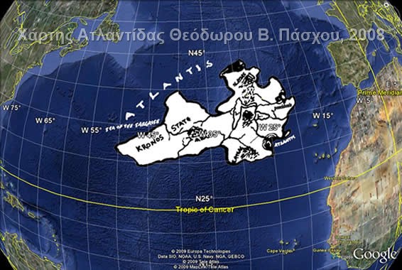
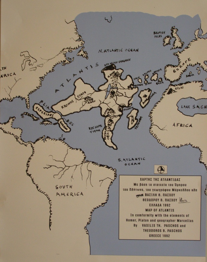
The Atlantis HypothesisThe 2nd International Conference on Atlantis was organized in Athens on the topic: "The case of Atlantis", on November 10 and 11, 2008 on the initiative of the "Society for the Study of Ancient Greek Mythology" (E.M.A.E.M.) and with the collaboration of selected scientists and independent researchers from Greece and abroad. The conference aimed to bring together experts from different disciplines to present scientifically substantiated views and constructively discuss issues related to or derived from Plato's text on Atlantis. And it was about a topic that is directly related to our country (Plato, Homer, ancient Athens, Greek mythology related to Atlantis) and that is why it is the most suitable country to conduct it and to deal with the issue of Atlantis that attracts the spotlight. The first conference was held again in our country, in 2005, on the island of Milos. The monitoring of as many visitors as possible highlights our country internationally as they are covered by many news agencies. More details are available on the event website (http://atlantis2008.conferences.gr) To express my point of view, which is the view of the Atlantis Museum, I participated in the Conference, as an independent researcher, with a poster presentation and an article, published in the proceedings, entitled:"New map for the Atlantis position- Atlantis was submitted to at least two disasters." See here the poster with the new map of AtlantisRead my article: "A new map for Atlantis - Atlantis gradually sank"
The closing of the ConferenceOn 11/10/2008 at 6.00 p.m. the Conference ended. During the two days that lasted, 34 posters were presented and 37 speeches were given by researchers from different countries. The opinions expressed were many, and in some cases diametrically opposed, but this fact was to be expected on such an issue. Of course, no one expected to find common ground in the discussion. But this does not diminish its value, and the scientific prestige of the presentations. It merely states that the issue of finding Atlantis is still hovering in the air, but at the same time, it is still of interest today. The time has not yet come for a final answer to this question (did it exist? Where? Or did it not exist?). ANYWAY IT WAS AMAZING! Many Thanks Thanks to the friends of Atlantis who responded to my invitation, but also to those who supported me
|
The conclusions of the Milos international conference confirm our researchScientists and researchers from 15 countries gathered at the Milos Conference Center from 11 to 13 July 2005 to share their views on the subject of Atlantis. Experts in the field of archeology, geology, volcanology and other sciences substantiated their views on this hypothesis. At the end of the Conference, in a special round table discussion, the delegates, by consensus, set out 24 criteria for locating the Atlantis resting place to be used by all seekers of lost land. Otherwise the search of Atlantis could well turn into a search for any lost civilization anywhere in the world. I consider that it was a serious, pioneering event for the Greek data, and the general final conclusions of the conference were important and fully confirm the research and theory of Atlantis' Museum that we have been formulating for many years. I present the following 24 criteria agreed upon by the delegates, which a geographical area must meet in order to be designated as the location of Atlantis::
Opinions were also questioned about the existence of Atlantis, mainly by Professor Christos Doumas, Director of the excavation of Cape Santorini and a member of the scientific committee of the conference, who argued that the "existence of Atlantis is a myth and its search is Utopia" An exhibition of books related to Atlantis was held in parallel with the conference. |
| Prehistory, Atlantis and "Gods": On Bluesky and Alter TV channels | |
I discuss on T.V. with L. Georgiadi (Bluesky, 8/7/2009) :1) Prehistory and Atlantis --- 2) The content of Vassilis Paschos book "The Atlanteans and Not the Gods" |
The view of "Atlantis Museum"My interview on the TV show "Gates of the Unexplained" |
Books Presentation |
||
Science Fiction
Author: Theodoros Paschos. Pages 320 Two Greek scientists with their technology find solution to the problem of communication with intelligent beings in the universe chasing the future of humanity. Seeking to solving various mysterious phenomena starring in Mission Teams to watch the flying saucers that appear on Earth to Mars and the Moon and to communicate with extraterrestrial beings. In doing so they get involved in adventurous and dangerous stories, but they also discovered the remnants of the technology of Atlantis into the ocean depth. You can preview or get the book from the Website: smashword.com/ |
The Atlanteans and Not the Gods
Author: Vassilis Th. Paschos. Pages 350 The author Mr Vassilis Paschos, with this book penetrates research into antiquity and by demystifying legends and traditions, proves the existence of the Atlanteans. For their original residence, the cradle of its culture, their lost country, the author quotes rich material and convincing facts ... |
Atlantes, Not the "Gods"
Αuthor: Vassilis Th. Paschos. Pages 80 The new and daring theory of Mr Paschos, is based on elements from Homer, Hesiod, Plato, Proklos, Plutarch, Markellaus and other ancient Greek and Latin writers (their works are mentioned in his book), on Egyptian papyrus, the Gilgames epic poetry of Babylonians, the Bible, the traditions of the people around Mediterranian and Central America and on ancient findings in these areas. You can preview or get the book from the Website: Smasword.com/ |